Posts

Showing posts from 2013

Last Day 2013

Image
In addition to the start of a new year, tomorrow is First Day Hike day.  Fifteen Washington state parks are hosting events (scroll down to Jan 1 here to find them all).  Tomorrow will be my third F.D.H. at Deception Pass State Park .  The itinerary will include the Discovery Trail and Goose Rock Summit (.pdf).  I can't think of a better way to start a new year. Last Saturday, I took a preview hike along the Discovery Trail and the nearby Lower Forest Trail.  What caught my eye were all the shapes, patterns and natural sculptures found in the forest.  Enjoy this album of Discovery Trail images as a preview of tomorrow's hike.  Then join us at the Cornet Bay Retreat Center  New Year's Day at 10:00 AM. Winter Rhododendrons promise springtime blooming. A Bigleaf Maple bends and twists to reach for precious light. Archways lead us into other worlds. Mists linger where the winds don't reach. Hair Lichens deco...

Pass Lake Loop Trail

Image
I had never explored the Pass Lake Trail in Deception Pass State Park.  It used to be a short, one-way trek which ended on Rosario Road.  From there it was necessary to either continue hiking on the road or turn around and return on the same trail.  I found neither option appealing.   On a newer map (.pdf) I noticed that it is now the Pass Lake LOOP Trail and it makes a complete circle back to the parking lot.  I decided it was time to check it out.  From Highway 20, turn onto Rosario Road at this sign (above).  Immediately turn right into the Pass Lake parking lot where there is a well marked trail head. On setting off, it is apparent that this is a Northwest Coast climax forest .  The dominant trees are Western Redcedar (Thuja plicata) , Douglas Fir (Pseudotsuga menziesii) , Grand Fir (Abies grandis) and Western Hemlock (Tsuga heterophylla) .  Where the canopy opens to let in a little light, there is Red Alder (Alnus rubra) and B...

New Feature on the Beach

Image
Late this afternoon as the sun was setting, I noticed a change on the beach.  That raised sandbar at the water line is new.  In my twenty-five years here, I have never seen this before.  Perhaps, I just never noticed it.  During the winter, it is unusual to see this much beach during daylight.  This time of the year, the lower low water tides usually occur in the middle of the night, or at least after dark.  It is not surprising to see no beach at all during daylight for a couple of months.  Today, the lower low water tide will be about 2 feet at 6:39 PM which is after dark.  The photo was shot at 3:54 PM with the water level at 4.84 feet according to my Tides and Currents app. These sandbars are formed by wave action and currents.  Usually, there is very little wave action in this part of Skagit Bay.  During fall and winter, however, windstorms can kick up a bit of surf.  This has not been a particularly stormy year, but we h...

Skywatch Friday:  Thanksgiving Dawn

Image
Happy Thanksgiving Ah lichtige Chanukah

November 22, 1963

Image
Photo:   Wikimedia Commons

Skywatch Friday:  Views From the Sky

Image
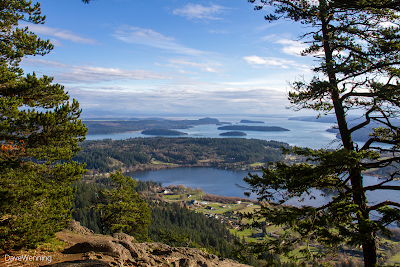
On Fidalgo Island, we can actually drive to the sky over a steep, narrow and winding road.  At 1,273 feet/388 meters Mount Erie is the highest point on the island.  This is where the sky begins for us.  The harrowing drive is worth the effort, but don't try it in ice and snow.  The views up here are spectacular making this Anacortes City Park a favorite spot for photographers.  These photos were taken November 19, 2013. Southeast:  The body of water in the foreground is Campbell Lake and beyond is Skagit Bay.  This is the same view as most of my other Skywatch photos , seen from a different vantage point.  The best time of day for this shot is late afternoon when the sun has moved over to the left.  The islands in Skagit Bay as viewed are as follows:                                                     ...

After the Storm

Image
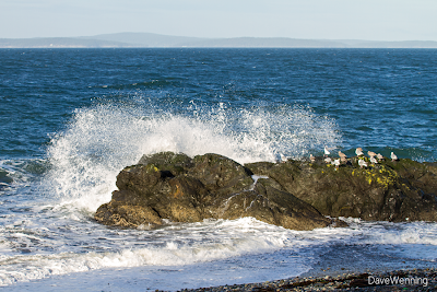
Last Friday, a classic November wind and rain storm passed through the area.  It rained fairly steadily all day.  My weather station measured 0.67 inch (17 mm).  All in all, it was a pretty miserable day.  On Saturday, however, the clouds parted to give us a nice sunny morning.  I headed over to Deception Pass State Park.  I have been watching the big rock near the West Beach parking lot .  It seems to be a favorite roosting spot for sea birds.  If the rock has an official name, I wish I knew what it was.  In the meantime, I have dubbed it Fraggle Rock after the Jim Henson/HBO TV series from the 1980's.  It's a little world apart where different creatures live in a complicated ecosystem and are  dependent upon each other for survival.  Beyond is Lopez Island in the San Juans on the horizon. The aftermath of the storm from the previous day was still apparent.  West Beach faces the Strait of Juan de Fuca and it was...

Skywatch Friday:  Holy Crap!

Image
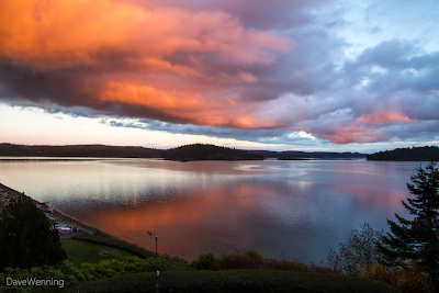
Holy crap!  That's what I said.  I was upstairs in my study working on the computer.  I came downstairs and literally thought the house was on fire.  The living room was glowing orange. Even though the view is southeast, this is sunset over Skagit Bay off South Fidalgo Island about 4:30 PM today.  I normally don't see sunsets because they are way over to the left hidden behind trees.  But on rare occasions I get front-lit sunsets like this.  That orange cloud formed a glowing band over my head from south to north.  This event lasted less than five minutes before it was completly gone.  Luckily, the camera was ready to go.