Posts

Showing posts from March, 2012

Navigating Deception Pass

Image
The Fidalgo Island side of Deception Pass is remarkable for the rocky headlands jutting into the waterway.  One is called Lighthouse Point.  The rock is volcanic, evidence of the fiery origins of many islands in this area.  Both the swift currents and these stony points can make transit a hazard for boaters.  The little navigation light in the upper-left corner of the photo has the job of guiding watercraft safely through the pass.  Lighthouse Point can be visited by following the trail that begins at Bowman Bay in Deception Pass State Park. The Lighthouse Point trail begins at the Bowman Bay parking lot.  Head south past the fishing dock to find the trail head.  I was seen off by a pair of Canada Geese.  The gander on the right gave me a look that said, "come one step closer and you'll regret it."  The trail begins with a steep climb with switchbacks.  Very soon, it levels off along the cliffside, then descends back down to the beach.  The rest of the way is an

Skywatch Friday: US Navy P-3C Orion

Image
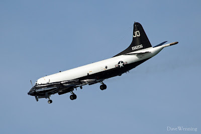
For this Skywatch photo, we leave our usual South Fidalgo camera location.  While visiting the West Beach area in Deception Pass State Park, I grabbed this quick shot.  There wasn't even time to check the camera settings.  This is a US Navy  P-3C Orion coming in for a landing at N.A.S. Whidbey Island .  Long range patrol is the aircraft's mission.  I also learned the stunning paint job is a heritage design from the 1960's.  This is part of the Navy's celebration of a century of naval aviation. Naval aircraft are part of the wildlife around here, a feature many of us enjoy.  You can Google the tail number for more details about this particular plane.

Storm Update

Image
9:24 AM, Temp 38.8° F, Dew Pt 30.0° F, Barometer 29.33 in, Wind 16 mph SE Gust 21, Hum 93% The worst of the March 12, 2012 windstorm has now passed through on South Fidalgo.  The barometric pressure appears to have bottomed at 29.327 in (993 mbar) at 9:06 AM.  Sustained winds in the 20's mph (30's+ kph) persisted through the night.  A peak gust of 33 mph (53 kph) occurred at 3:14 AM and there were several during early morning hitting 31 mph.  I woke to the sounds of driftwood logs hitting the seawall.  It's a deep resonance that vibrates through the ground and up into the house.  Since about 6:00 AM it has been raining fairly hard in our classic sideways pattern. This is the regional NOAA Satellite Image at 1730 GMT (10:30 AM PDT).  It shows the spiraling storm center crossing Vancouver Island and entering the interior of British Columbia.  The mottled area over the Pacific being drawn in behind the storm is cold air.  This is why our forecasts show some snow mix

Incoming Storm

Image
5:21 PM, Temp 45.9° F, Dew Pt 40.3° F, Barometer 29.70 in, Wind 12 mph Gust 27 mph, Hum 80% A major windstorm is approaching the Washington coast.  It is expected to arrive tomorrow night and into Monday morning, but it is already getting windy here now.  Winds could approach 60 mph/97 kph along the coast and here in the Northwest Interior.  Areas along Vancouver Island, Canada could see 100 mph/161 kph winds.  If we have power, I will try and update the situation on Monday. Here is the current text from the National Weather Service: ...HIGH WIND WATCH IN EFFECT FROM LATE SUNDAY NIGHT THROUGH MONDAY AFTERNOON... THE NATIONAL WEATHER SERVICE IN SEATTLE HAS ISSUED A HIGH WIND WATCH...WHICH IS IN EFFECT FROM LATE SUNDAY NIGHT THROUGH MONDAY AFTERNOON. * SOME AFFECTED LOCATIONS...HOQUIAM AND FORKS ON THE COAST...PORT TOWNSEND...AND WHIDBEY AND THE SAN JUAN ISLANDS. * TIMING...A STRONG FRONT WILL MAKE LANDFALL LATE SUNDAY NIGHT AND MONDAY MORNING. * WIND...SOUTHEAST WINDS

The W.T. Preston

Image
The Snagboat W.T.Preston is a stern-wheeler on permanent display adjacent to downtown Anacortes, Washington.  Head down R Avenue and you will spot it on the north end of the Cap Sante Boat Haven.  Shallow-draft  Snagboats worked to remove navigation hazards from the rivers along the length of Puget Sound including the nearby Skagit.  The Preston operated from 1929 to 1981 and is on the National Registor of Historic Places.  The seagull headed for the pilot house is not. Weather Statistics for February, 2012 Temperature High 60.2° F Low 27.9° F Mean 42.5° F Rainfall 3.01 inches Wind High 34 mph Average 2.5 mph Dom Dir SSE Observed at South Fidalgo Island (See Climate page for complete climatological data)