The Last Trail: Goose Rock to Cornet Bay Road
No, I am not giving up hiking. When I say the "last trail," I am saying with this hike, I have completed every official trail in Deception Pass State Park. This one opened last fall and doesn't even have a name or appear on the park's trail map (.pdf). Park staff just refer to it as the Goose Rock-Cornet Bay Road trail. It branches south from the trail that connects the Park Administration Building with the Goose Rock Perimeter Trail. For this hike, I parked at the Admin Building and headed down the trail towards Cornet Bay. Find a map of the trail on page 6 of the October, 2015 issue of The Current (.pdf).
The weather was atypical for July. I set off under an overcast sky in occasional light drizzle. The temperature was a comfortable 57° F, 14° C. The forest would be my umbrella. I remained dry the entire hike.
The trail begins like most of the others in the park. It's a closed canopy coniferous forest trail bordered by shrubs, plants and mosses. This is now a segment of the 1,200 mile Pacific Northwest National Scenic Trail that runs from the Continental Divide in Montana to Washington's Olympic Peninsula coast. The new trail eliminates the need for hikers to wander through campsites or walk along the highway.
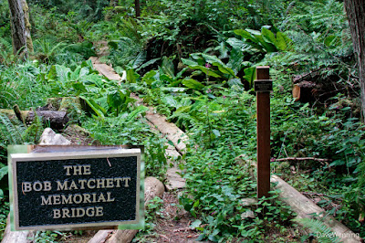
As I proceeded, I noticed the canopy starting to open up ahead. I found myself at the edge of a wetland. What allowed the formal opening of this trail was the construction of a puncheon-style bog bridge through the wetland by volunteers from SWITMO. This has also become a primary point of interest on the trail. Before the bridge, this bog area had been virtually impassable. The wetland has now become a destination, a reason to hike the trail.
The insert in the upper photo shows the plaque that dedicates the bridge (.pdf) to the memory of Bob Matchett, an outdoorsman and SWITMO volunteer. He had worked on creating this trail. When he passed away, the organization chose this bridge as a fitting memorial.
When I started across, I expected the bridge to bounce and slosh in the mud. It didn't. It was rock-solid, as stable as any concrete sidewalk I have ever traversed. I congratulate the guys from SWITMO on this engineering feat in such a difficult place. Since keeping my feet dry is always a goal, it is greatly appreciated.
Cooley's Hedge-nettle (Stachys cooleyae) and Queen Anne's Lace (Daucus carota) were blooming all around the bridge. I could also see remnants of spring wetland wildflowers, especially Skunk Cabbage and False Lilly-of-the-Valley. I will definitely be adding this trail to my spring rhododendron and wildflower treks. It's a convenient extension to the Goose Rock trail network.
The trail ends at Cornet Bay Road near the State Park Retreat Center driveway.
From the Admin Building or Quarry Pond Campground to Cornet Bay Road and back is an easy one hour hike. There is no difficult terrain. Allow more time if you stop to look at things like I do.
Shady Way, Hoypus Point
Earlier this week, I checked off the Shady Way Trail at Hoypus Point. This was the only trail in the Hoypus network I had not yet explored. It's a short trail, but you need to cover a lot of ground to get to it. Altogether, this ended up a three hour hike. The photo shows the junction to Shady Way (left) from the North Fork Trail. Hoypus is a fascinating, primitive area of the park for hiking. I'll be returning there many more times.
One way to describe Deception Pass State Park is "4,000 acres with 50 miles of trails." Completing these two trails, and thus all the Deception Pass trails, is a milestone for me. Nevertheless, I know I have only scratched the surface. I am also learning there are more "unofficial" trails to be discovered. I am not finished exploring this great state park. As commemoration, here is a quick list of all the trails I have hiked in the park:
- Bowman Bay to Rosario (the first trail I ever hiked at Deception Pass, 58 years ago)
- Bowman Bay to Lighthouse Point
- Lotte Point
- Bowman Bay to Pass Lake
- West Beach Sand Dunes
- North Beach
- Cranberry Lake to West Beach
- Upland Interpretive Trail
- Discovery Trail
- Lower Forest Trail
- SE Goose Rock Summit
- SW Goose Rock Summit
- NW Goose Rock Summit
- NE Goose Rock Summit
- Goose Rock Perimeter
- Discovery Trail to Park Admin Building
- Pass Lake Loop
- Ginnett Hill
- John Tursi Trail
- Cornet Bay Road
- West Hoypus Point
- East Hoypus Point
- CCC Crossing
- Fireside Trail
- Little Alder Trail
- North Fork Trail
- Forest Grove
- Fern Gully
- Hemlock Hideaway
- Big Marsh Trail
- Slug Slough
- Short Trail
- Old Hoypus Logging Road
- Julie Trail
- Shady Way (earlier this week)
- Park HQ to Cornet Bay Road (this hike)


